Block14 · Massing study
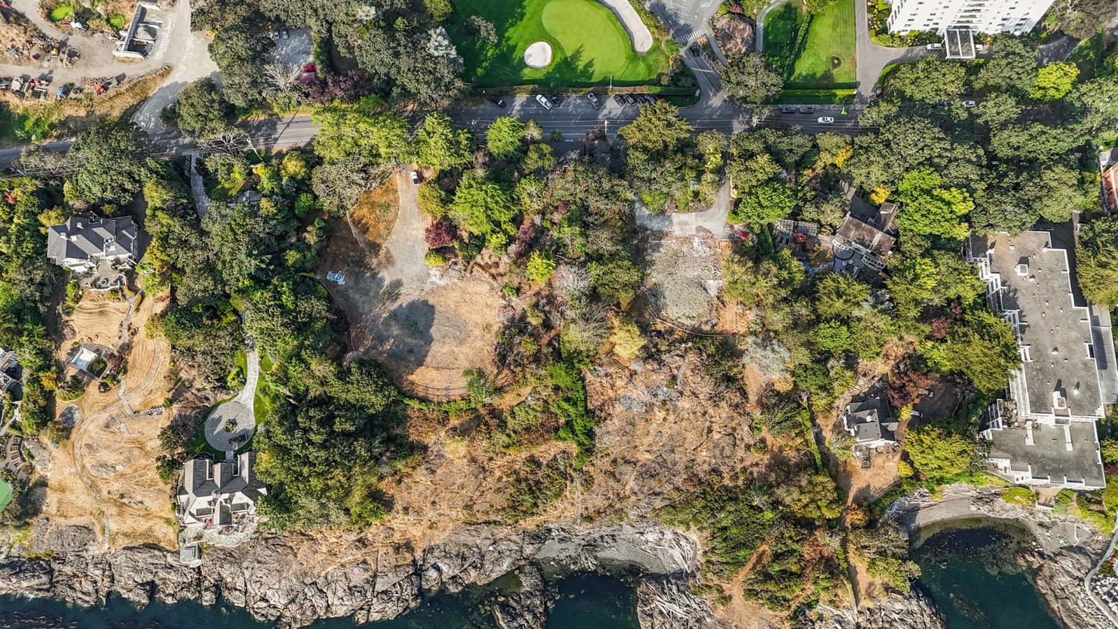
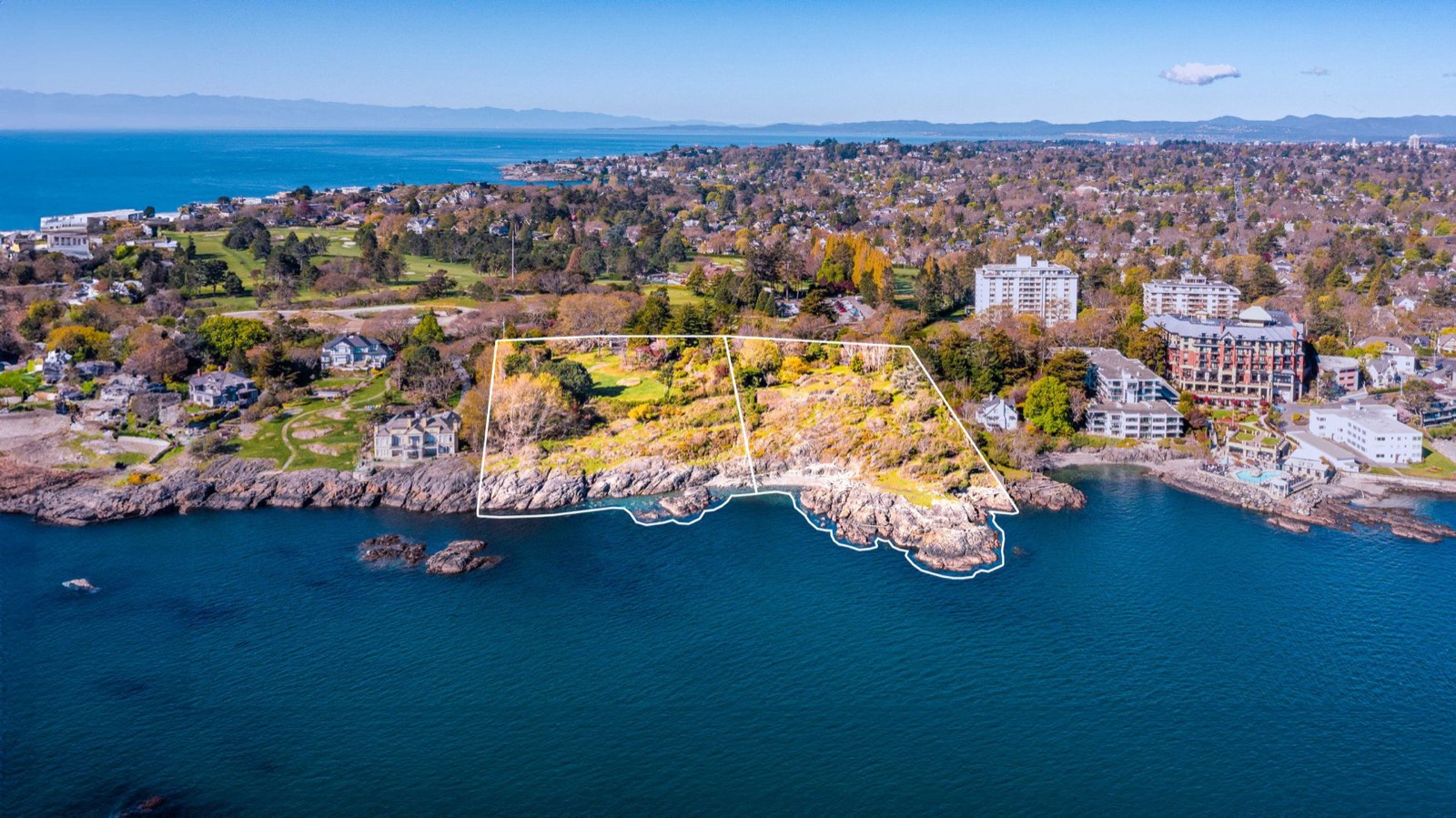
Aerial photograph of 1069 and 1101 Beach Drive with both property boundaries outlined in white on a rocky headland facing Haro Strait
1069 & 1101 Beach Drive · Oak Bay · Massing study, 18 September 2026

What fits on the land

The site is bigger and better shaped than the sale listing suggests, and the rules take less of it than you might fear. This is what a terraced, residences-only concept of about 205 homes looks like drawn onto the actual ground.

The land

Two lots, roughly 600 feet wide and 375 feet deep

The "1,000+ feet of shoreline" in the listing is measured along the indented rock, not across the property. In straight-line terms the assembly is about 600 feet of frontage by 375 feet of average depth: 225,205 sq ft, or 5.17 acres. That shape matters more than any other single fact about the site, because it is deep enough to hold several buildings and a courtyard instead of one fat tower.

ParcelAreaFrontagePosition
1069 Beach Drive2.90 ac~280 ftWest lot. The 1912 Rogers house (later the Ross family of Butchart Gardens) stood here until 2024.
1101 Beach Drive2.24 ac~320 ftEast lot. Anketell Lodge, 1914, demolished 2024.
Assembly5.17 ac~600 ft225,205 sq ft on two titles. Cleared and surveyed.

What is actually around it

  • North: Beach Drive, then the Victoria Golf Club fairways directly opposite.
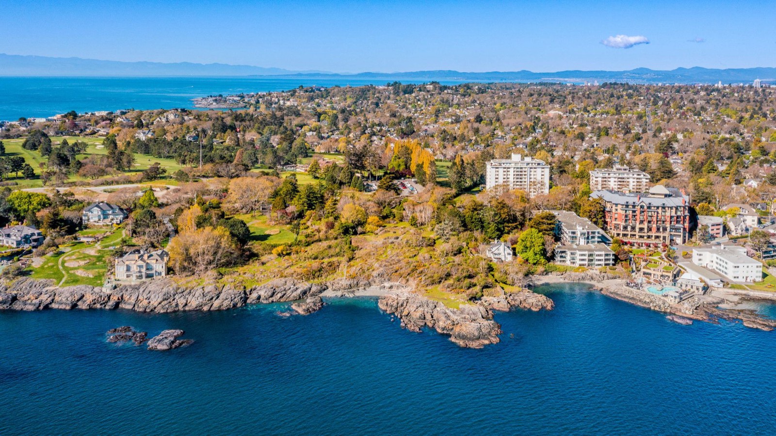
  • East: a single neighbouring house, then an existing 11-storey apartment building, then the Oak Bay Beach Hotel. The tall building is the height precedent nobody mentions.
  • West: two large waterfront houses on their own grounds.
  • South: a rocky headland with one pocket cove, offshore reefs, and open water to Haro Strait, Mount Baker and the Olympics.
  • On the site: two cleared house pads, a mature perimeter tree canopy, and a band of trees through the middle.
Oblique aerial from the water looking north: the cleared site sits between waterfront houses to the west and an eleven-storey white apartment building and the Oak Bay Beach Hotel to the east, with the Victoria Golf Club behind

Looking north from the water. The site is the cleared, grassy ground at centre. Note the existing 11-storey apartment building to the right of it, and the Oak Bay Beach Hotel beyond: this is not an untouched stretch of coast, and the neighbours are already multi-family.

Constraints

What the rules carve away, drawn to scale

Four rules shape the envelope before an architect draws anything: the shoreline setback, the flood construction level, the tree canopy, and the height the Official Community Plan contemplates. Together they remove about a fifth of the site and set the form of what is left.

Haro Strait Beach Drive · Victoria Golf Club opposite Frontage setback, street trees, promenade link Buildable envelope ~177,000 sq ft · about 590 ft × 300 ft Shoreline Development Permit Area · 15 m (49 ft) setback ~1.1 acres · no building · this is where the public promenade goes Natural boundary ~600 ft straight-line frontage (~1,000 ft measured along the rock) ~375 ft average depth

Drawn to scale. The shoreline setback is the only rule that removes real area, and it removes the part you were never going to build on: the rock. Source: R&D/08-site-technical-schedule.md, Oak Bay OCP s.8.2.2.

Flood construction level

Ground floors sit up

Habitable floors must clear a level set for 1.0 m of sea-level rise by 2100 plus 0.6 m of freeboard, estimated at 5.3–6.8 m above datum. Near the water that is above the road. It raises the water-edge buildings on a plinth, which is a design opportunity as much as a constraint.

Trees

2:1 replacement inside the envelope

The perimeter canopy is the site's best asset and the cheapest goodwill available. Keeping the frontage and side belts intact does more for the application than any rendering.

Height

12 storeys is the ceiling, 6–8 is the conversation

The OCP's multi-unit benchmark caps at 12. Aryze is asking for 8 next door at 951 Beach. The apartment building already standing to the east is 11. Anything in the 6–8 band has three separate precedents behind it.

The site plan

A terraced village, not a tower

Massing drawn onto the vertical aerial. Three building groups step down from nine storeys at Beach Drive to four at the water, split by two view corridors that run clear from the road through to Haro Strait. The shoreline stays public. This is the shape that answers the 2025 objection instead of repeating it.

Vertical aerial photograph of the site with Beach Drive across the top and the rocky shoreline across the bottom RENTAL · 6 9 st 8–9 st 6 st CLUB 6 st 4 st 4 st 4 st view view corridor public shoreline promenade Beach Drive 1101 1069 ← lot line → 1101
8–9 storeys, road edge 6 storeys, middle terrace 4 storeys, shoreline homes Nations-owned rental building Residents' club Shoreline setback, kept public View corridors

Indicative massing, not architecture. Footprints are placed to scale on the vertical aerial and are accurate to roughly ±10%. No architect has been engaged and the Special Study Area framework will shape the final form. Base image: listing aerial, 01-Listing/photos.

Move 1

Break the mass into three

Eight residential buildings and a club in three terraced rows, none long enough to read as a wall from the water or the golf course. The 2025 scheme put 568 homes in two slabs; this puts about 205 doors in pieces you can see past. Floor-space ratio lands near 2.4 on the buildable area, below the 2.96 the neighbouring proposal is asking for.

Move 2

Two view corridors, road to water

Roughly 60 and 80 feet wide, clear from Beach Drive through every row to the strait. Oak Bay's own community letters asked for exactly this. Committing to them in writing, before the framework starts, is cheap and disarming.

Move 3

Give the shoreline away

The 49-foot setback becomes a public promenade on a statutory right-of-way, linking Aryze's walkway at 951 Beach east toward the hotel and Turkey Head. The policy asks for a continuous public walkway; this is the only site that can deliver the middle of it.

Section

How it steps down to the water

One level of parking on bedrock · ~200 stalls 8–9 storeys64 promenade flood construction level (2100 + freeboard) Beach Drive Haro Strait every row sees over the one in front ~375 ft, Beach Drive to the natural boundary

Indicative section. The ground already falls from the road to the rock, so terracing works with the land rather than against it: each row looks over the roof of the one in front, and the tallest mass sits furthest from the water and closest to the existing 11-storey neighbour. The nine-to-six-to-four step keeps that relationship even at the greater height.

Why terracing is worth more than height. On a flat site, view value forces you upward. Here the fall of the land does the work: a third-floor home on the middle terrace can hold the same outlook as a sixth-floor home at the road. That is what lets the road edge carry nine storeys while the water edge stays at four, and it is why going up adds homes without adding the visual bulk that sank the 2025 scheme.

Height in context

What was proposed in 2025, and what this is instead

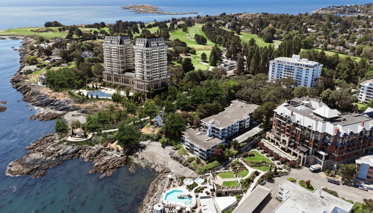
Developer rendering from the 2025 listing showing two towers of about twenty storeys on the site beside the Oak Bay Beach Hotel

2025: 568–582 homes, two towers of 18–20 storeys. Filed as a rezoning in May 2025, deemed incomplete twice, never opened by the District. Oak Bay responded by writing the whole stretch into the Official Community Plan as a Special Study Area. This is the image the community remembers.

05101520 OCP ceiling · 12 storeys 2011894 2025towers neighbournext door Aryze951 Beach Block14road edge Block14at the water

Storeys. The scheme's tallest element is still two storeys shorter than the apartment building already standing next door, three below the Official Community Plan ceiling, and one above what the neighbouring proposal is asking for.

The towers are withdrawn. The 2025 concept is the only thing most people in Oak Bay know about this land, so it is worth saying plainly rather than leaving it to be assumed: it will not be resubmitted by Block14 in any form, and a commitment to stay within the Official Community Plan’s height framework will be put in writing before any application is prepared.

Programme

What sits in each piece

Indicative yields from the massing above. The mix of homes is a working set for discussion, not a final schedule, and no home is being offered or reserved.

ElementStoreysFootprintFloor areaHomesNotes
Road-edge buildings (2)8–9~21,000 sf~185,000 sf~80Largest homes and the penthouses on top, looking over the lower rows. Two storeys below the existing apartment building next door.
Middle terrace (2)6~16,000 sf~95,000 sf~41The core two- and three-bedroom product for Oak Bay downsizers.
Shoreline homes (3)4~17,000 sf~67,000 sf~29House-substitutes with their own entries, set behind the 49-ft setback and raised to the flood level.
Residents' club2 + lower~8,200 sf~32,000 sfPool, spa, fitness, lounge, cinema, guest suites, opening south to the water.
Nations rental building6~8,500 sf~51,000 sf~55Owned outright by a Songhees–Esquimalt vehicle, built at cost, separate entrance off Beach Drive.
Parking1–2 below~90,000 sf~255 stalls at the current bylaw ratio: one full level plus a partial second under the road-edge buildings. Drill-and-blast on bedrock.
Total4–9~71,000 sf~430,000 sf~150 market
+ ~55 rental
About 40% site coverage. Floor-space ratio ~2.4 on the buildable area, ~1.9 on the whole site.

Why the height steps the way it does. Carrying eight or nine storeys at the road edge, six on the middle terrace and four at the water adds homes without widening a single footprint, so site coverage stays at about 40% and the shoreline edge stays low. The tallest element sits two storeys below the apartment building already standing next door and three below the ceiling in the plan, and it sits at the end of the site furthest from the water. That is the trade the form is making: density where it is least visible, openness where it matters most.

Phasing

East first, west second

Phase 1 is the eastern group plus the club: nearest the hotel and the existing apartment building, furthest from the golf club, and the least contentious ground to build on first. Phase 2 releases the western group once Phase 1 is about 65% presold. The Nations' rental building goes in Phase 1, so the community benefit lands early rather than being promised late.

What the shoreline gets

Promenade, restoration, launch

A public statutory right-of-way the full width of the site, naturalised planting on the setback band, a small craft launch at the cove, and a seawall engineered to the sea-level-rise criteria, all gifted to the District. It connects toward 951 Beach in one direction and the hotel and Turkey Head in the other.

Massing arithmetic derived from the Oak Bay Official Community Plan (shoreline development permit area, height framework), the District’s parking and tree bylaws, and provincial flood construction guidance.
Standing

What this is, and what it is not

It is

A massing study on real geometry

  • Footprints placed to scale on a vertical aerial photograph, accurate to roughly ±10%.
  • Built from the actual constraints: the 15 m shoreline setback, the flood construction level, the parking ratio, the tree bylaw and the height framework in the plan.
  • Enough to show neighbours, the District and the Nations the shape of what is being contemplated, early and in the open.
It is not

A design, an application, or an offer

  • No architect has been engaged. There is no floor plan, elevation or material behind these blocks.
  • Block14 does not own this land, and no application has been filed with the District of Oak Bay.
  • The comprehensive planning framework for this stretch of Beach Drive has not begun, and it will shape height, view corridors and setbacks. That is the point of going framework-first.
  • The survey, geotechnical, archaeological and coastal work that would confirm any of this is still to be completed.
  • No home shown here is being marketed, offered or reserved.